Features Planning
Find out what is four hours from here
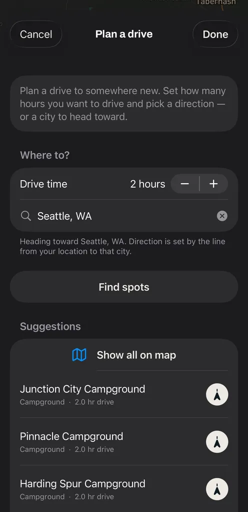
Some days the question is not where, it is how long to drive for. The Plan a Drive feature takes a number of hours and a direction, or a city to aim at, and brings back spots whose real driving time lands inside that window, measured along actual roads instead of guessed from a circle drawn on a map.
How it works
-
Set the hours and the heading
Open Plan a drive, set a drive time of up to twelve hours, then either pick a compass direction or type a city to head toward. Vroam keeps candidates within about forty-five degrees of that heading, so you are not sent sideways.
-
Tap Find spots
Vroam asks Mapbox for real driving durations to the candidates out there and keeps the ones landing within about forty-five minutes of your target. Anything in the right direction but closer than your window gets grouped separately under On the way, in case you would rather stop early.
-
Preview the drive, then hand it off
Put the results on the map and pick one to preview the drive: distance, time, and an elevation profile of the drive you can drag through. Stops can be reordered or removed. When you are ready to actually go, Vroam passes the destination to Apple Maps or Google Maps.
What makes it different
The window is measured with real driving durations from the road network rather than a circle drawn at an assumed average speed, so a mountain pass between you and a spot pushes it out of range the way it does in real life.
What is a drive time radius, and why is it not a circle?
A drive time radius is the set of places you can reach within a given time on the road. Drawn as a circle it is almost always wrong: an hour on an interstate covers three times the ground an hour on a forest road does, and a river or a mountain range can leave a place thirty minutes away in a straight line and two hours away by car. The honest version measures time along real roads, which is what a routing matrix does. It asks for the driving duration from one starting point to many destinations at once, so the shape it produces is lopsided in exactly the way the road network is.
Common questions
- Does Vroam route around low bridges or clearance limits?
- No. It does not route around low bridges, tunnels or restricted roads, and the driving profile behind a preview is a standard car profile. What Vroam does instead is check your rig against the limits a destination documents, which is a different job. Watch posted signs on the way.
- Can I plan a trip with several stops?
- Yes. A route can carry several stops, and you can drag to reorder them or swipe to remove one while the route rebuilds as you go. One thing to know: the handoff to Apple Maps or Google Maps sends the final destination only, so intermediate stops do not travel with it.
- Is this turn-by-turn navigation?
- Not in the way a navigation app is. You get the steps of the drive, an elevation profile and your position along the line, but no voice guidance, no live traffic and no automatic rerouting. That is why handing off to Apple Maps or Google Maps sits right there in the app.
- What if nothing comes back?
- Usually it means the spots that are loaded do not line up with your direction and time. Try a wider direction, a different number of hours, or zoom the map out first so more of the area is loaded before you tap Find spots.
Vroam is coming to iOS, with Android in build.
Free to start. Pro is coming after launch.
Notify me at launch